PCT Day 110 – The Weather Outside is Weather

Campsite at mile 1566 to Statue Creek (mile 1591)

The afternoon finds us repeatedly climbing along high ridgelines just as the sky curdles over and thunder rumbles overhead. Exposed ridges with thunder, possibly my least favorite combo. If clear skies and sunny mountain tops are peanut butter and jelly, then exposed ridges and thunder is a pickle juice and vanilla ice cream shake. Ever since an especially wet llama-packing trip with my family on the Colorado Trail found us huddling under trees while the skies turned white with lightning, I have been uncommonly nervous during thunderstorms. But I’ve also never been struck by lightning, so maybe I’m doing something right.

As we hike towards evening a frustrating pattern emerges. We scramble up and over a ridge just as the skies turn grey and ominous, I’m pushing the pace faster and faster in my nervousness to get back into the trees, back to where I’ll be relatively safe. As we crest the ridge it starts to sprinkle, or rain, or hail on us. Once we even stop to put on our rain gear, huddling under the eves of a scrawny pine tree working our damp arms into damp rain jackets while slushy hail turns the ground white around us. However, within ten minutes the sun is pushing through the clouds, the temperature and humidity shooting up along with it and we’re shedding layers as we begin to sweat. Then it starts to rain again and I completely give up. It’s not that cold, I’ll just be wet. Fine, it’s fine.

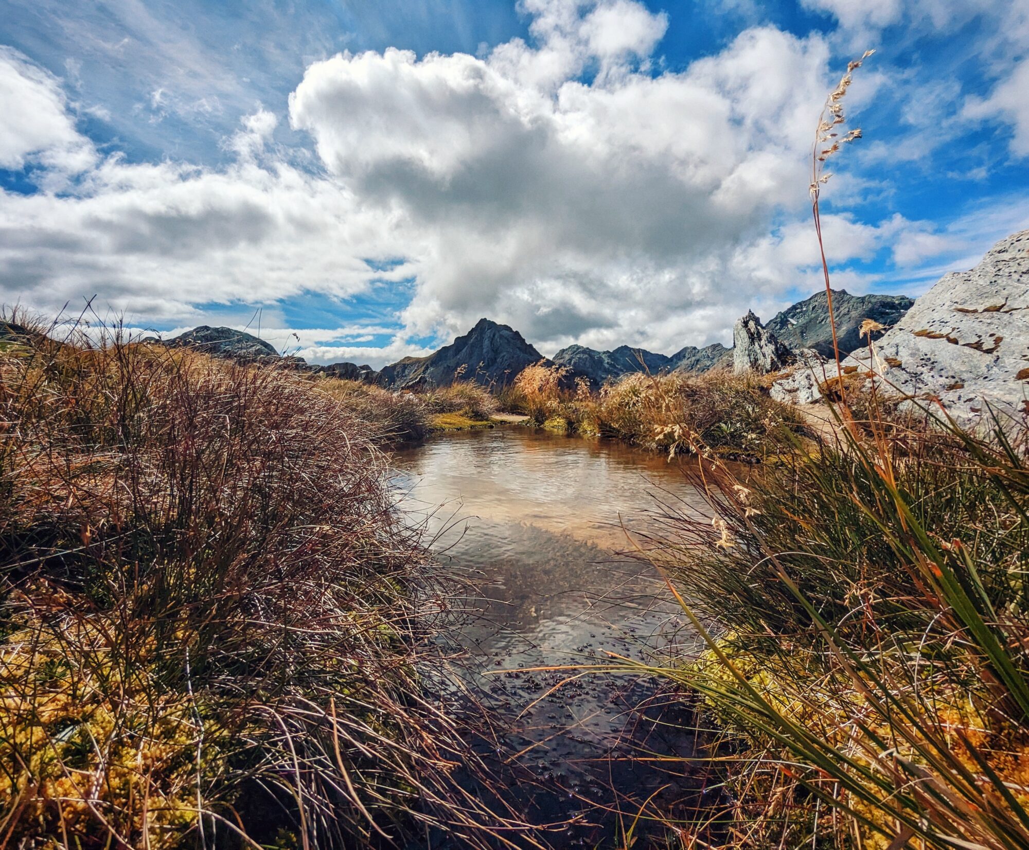
The sun is edging towards the horizon as we make our way up the last climb of the day. Far below and away until forever stretch tree filled valleys and tree covered ridges, row upon row. The rain clouds have finally ceded their efforts to the sun, with it’s humidity and haze, which dumps its warm syrupy yellow light across the world and all the way down into the deep valleys with their little ink black lakes. I always wonder what is down in those valleys, or over the next ridge—what special things are hidden behind those trees. I always have wondered what is just beyond what I can see, even if I know I’ll probably never go there, I want to know. I always want to know. The PCT takes one to a lot of different places, but only in its unique ever-moving way. The trail doesn’t always lend itself to exploration, or rather it is a very specific sort of exploration. Not the meandering sort of curiosity wandering, but rather the way in which you can see new vistas from the passengers seat during a road trip. An ever moving bubble of new sights, but you won’t get to see what’s beyond that ridge. We can look, but not touch. In this way NorCal feels vast and endless, the hazy sky smearing the edges of everything until maybe that distant ridge really is the end of the world.

PCT Day 109 – The Madness of Northern California

Campsite at mile 1543 to campsite at mile 1566

The thing about the Pacific Crest Trail is that it only travels north on average; on any given mile or day you may be heading in the complete wrong direction—as we are now. Today Mount Shasta poked occasionally over the eastern horizon, which was great because it meant that I could clearly monitor all the progress we were undoing as the trail wound south. In between crossing under the I-5 and reaching the road that will take us into Etna, the trail hangs a large scraggly S turn. We are no further north today than we were yesterday, despite the 23 trail miles that were hiked. This is exemplary of so much of what happens during the course of waking the height of a country, which is to say seemingly irrelevant bull waffle.

Today much of the scenery was reminiscent of Southern California—hot hazy mountains set in rows of receding ridges that eventually drop into a flat basin town. Then it was chaparral dropping towards Los Angeles , now it is pine forest fencing in Redding, but the endless marching forests feel the same. The shuttered views under the blazing sun, hard rocky ground under foot. The sensation, the memory of those days hiking along the ridges of Los Angeles felt so familiar and close, that when I pull my mind back to the present it feels akin to time travel. It suddenly felt impossible that I could have walked the land between these two points. That I had hitched in to and out of dozens of small towns, eaten unknown general store hamburgers. Certainly no. How is it that of all the people we started with, of all the hopeful hikers who stand at the southern terminus in early spring, I am still walking? The scope of the thing is almost overwhelming in it’s confirmation that we are, that I am doing this hard hard act. The reality settles upon me like warm summer rain, seeping under my skin until it is part of who I am.

PCT Day 108 – The Dirtiest Thirty, Round 2

Campsite at mile 1520 to campsite at mile 1543

My first roommate after college was a man who loved birthdays. His especially, but truly he was a fan of celebrating anyone’s birthday. So much so that when he discovered my birthday approaching, and that I didn’t plan to celebrate, he cajoled me into planning and hosting a party I never wanted.

You see, I’ve never particularly liked birthdays—especially my own. As a kid I was grateful that my birthday fell during summer vacation, so I wouldn’t have to bring in cupcakes and be sung to by the entire class. I am deeply uncomfortable with being the center of attention, something which most public birthday celebrations tend to dictate. Additionally, aside from your first birthday, your literal day of birth, the pomp and circumstance seems a little forced. Am I really all that different today than I was yesterday? Is 30 years terribly significant when compared to 29 years and 364 days? And beyond all that, each yearly demarcation seems more akin to the gradual loss of youth, of life, than a celebratory occasion; the evaporation of potential as it settles into the people we become. The people we will one day die as—and if we may be so lucky, remembered as.

Perhaps it was fitting, then, that today was nearly indistinguishable from an ordinary hiking day. We woke later than we intended to, and spent the day in slow, partial circumambulation of Mount Shasta. Rolling up and over low ridges under leaden grey clouds which threatened rain all day, but only managed to work up the spottiest sprinkle in late morning. The views were unphotogenic, faded by humidity and haze as they were. Only the wild flowers truly shone under the cool soft light which emphasized their vibrant colors.

While I walked I listened to the endlessly comforting Harry Potter audio books; a series I return to for their soothing nostalgia and familiar narrative. Choosing to send my mind to another world while my body marched relentlessly across the fields of our own. Today I did not feel compelled to circuitously ponder the significance of this particular birthday, this long coming decade change that seems to indicate real deal adulthood. I didn’t particularly wish to spend my hours of walking thinking of my patchwork creative career, so varied and incongruous. Nor did I feel drawn to think the mightiest of questions, the one which I have returned again and again during this hike: what am I going to do with the rest of my life? Our phrased more explicitly – In this capitalist society, in which I have no choice but to win the lottery or else work in order to provide for myself, what can I do with the skills that I possess that will pay the bills, and also provide creative nourishment, in which I don’t feel like I’m selling my soul in the aim of selling products?

So I gave myself the gift of not having to think about the impending termination of this adventure and the chasm of uncertainty that waits beyond. However, if you have any career or life advise, consider it welcome. I have found that even terrible advise can yeild good ideas.

PCT Day 107 – Northbound Again, Finally

I-5 outside Dunsmuir (mile 1501) to campsite at mile 1520

On paper, today had a lot going against it. The first being temperatures over 100 in the valleys. The next being the plan to hike 19 miles in said heat, with 6,000 feet of gain; if anybody tells you that the PCT in Northern California is flat, you punch them right in the face and tell ’em Kara sent you.

Yet despite all of that, today was one of the glorious high points on the emotional and physical rollercoaster that is long distance hiking. Because today, after weeks and weeks of going the wrong direction, long winded explanations of our plans, and swimming salmon-like against the onslaught of NoBo thru hikers, we finally started walking towards Canada again. Finally. The endless northern California trees with their neon green moss—which I had grown so tired of previously—have regained their stalwart beauty. My legs felt strong and capable, and even fast as we made our way down the hard packed dirt trail, perfect under foot with it’s patina of fallen pine needles. The comparable glut of oxygen at these lower altitudes made the unending climb feel more than simply achievable, but like I have finally maybe turned from a soft city creature into a mountain mammal. These forests are my home now, I can live and thrive here.

All day we cut a lazy arc around Castle Crags, their reaching granite turrets reminiscent of the Sierra to the south, yet uniquely themselves. On the northern horizon sat the giant slumbering form of Mount Shasta, while to the south Mount Lassen broke the skyline in reflection. From here to the border everything is new, every mile untread by either Keith or myself. We are finally looking forwards to the finish line, Canada pulling us towards her like an invisible undercurrent sweeping out to sea and I will not fight her, but allow myself to be pulled by the hand like a restless child.

PCT Day 106 – SoBo Flip – U-Turn

Zero in Reno plus a drive to Dunsmuir, no hiking

Total PCT miles hiked: 1400

Due to our early start Keith (Starman) and I arrived at the Sierras when there was still a lot of snow, and decided it wasn’t safe to attempt a crossing given my skill level. We elected to flip up to northern California and hike southbound (SoBo) back to where we left off near Lone Pine – giving the snow a chance to melt out. During this flip the PCT milage will be counting down, but I’ll include a tally of our total milage hiked so that you can keep aprised of our progress in a linear fashion.

By the time we arrive at the hotel in Dunsmuir my only thought is how tired I am. The previous day’s hitch hiking marathon, followed by today’s long drive to Redding and an hour long Lyft ride to Dunsmuir has left me wilted. But we don’t have anything for dinner, so we leave the blissfully cool darkness of the hotel and wander into downtown Dunsmuir in search of sustenance.

The small grocery store is a sorry sight for hungry hikers—I swear they have a bigger dog food selection than human food. Eventually I cobble together a meal of whipped cream and strawberries, and an avocado and Keith gives up on the grocery entirely and orders a pizza which we walk down the street to pick up. The sun is blazing hot even as it works it’s way towards the horizon. It’s only a mile back to the hotel, but in my current state of exhaustion that feels like walking to the moon.

Walking into Gary’s Pizza Factory Keith sees the sign for delivery and jokes that we should get them to deliver us back to the hotel along with the pizza. Genius. Except when he goes to pay he doesn’t ask if they’ll give us a ride. Coward! Engineer, socially awkward coward! But if my mom taught me one thing it’s that you might as well ask for what you want, the worst they can say is no. With my remaining energy I muster a smile and ask the lovely women who are working behind the counter if they would be able to give us a ride back to our hotel. And because the world is mostly full of kind people, they say yes.

I’ll walk over 2,000 miles to get to Canada, but no way I’m walking the mile to get back to the hotel, not if I can help it.

PCT Day 105 – SoBo Flip – How to Hitch to Reno

Traveling zero as we complete our SoBo Flip, no hiking

Total PCT miles hiked: 1400

Due to our early start Keith (Starman) and I arrived at the Sierras when there was still a lot of snow, and decided it wasn’t safe to attempt a crossing given my skill level. We elected to flip up to northern California and hike southbound (SoBo) back to where we left off near Lone Pine – giving the snow a chance to melt out. During this flip the PCT milage will be counting down, but I’ll include a tally of our total milage hiked so that you can keep aprised of our progress in a linear fashion.

Here is how you hitch from Bishop, CA to Reno, NV in 9 easy steps.

1. Wake early in the blissfully cool guest room at Julie’s house and spend ten minutes marveling at the glory that is a real bed before putting on damp clothing that has almost, but not quite, dried over night. Finalize packing an enormous box full of all the items one no longer needs after the Sierra—ice axes, bear cannisters, extra warm layers, and micro spikes—and send them to your very very kind and patient friend Ian who is wonderfully holding all your items until you’re off the trail. At 8am walk to Enterprise Car Rental and grab a large coffee on the way. The coffee is important because when you arrive at Enterprise you’ll discover that the are no cars to be rented, there are no other rental companies between here and Reno, and the only bus going north has already departed for the day. Leave the rental car company and step into the already too hot day, feel the high sun begin to roast your skin with the promise of summer in the desert. On the walk back to Julie’s recognize that hitchhiking is your only option to get to Reno, the only option to get a rental car, the only option to get back north and back to the trail.

2. Accept your fate, get stoked for some Type 2 fun, and make the best hitchhiking sign you can.

3. Take up a spot on Bishop Main Street, grateful for the fact that you get to hitch from the shady side of the road. Move when a car parks right in front of you. Move again. Move again as more cars roll onto Main Street to start the work day. Move one last time for good measure.

4. Catch your first ride of the day with Liz, a school teacher from Mammoth Lakes who has a daughter living in Australia working with abused women, and a son working as a smoke jumper in Colorado. Ride with her to an off ramp near Crowley Lake along the 395. Stuff down the fear that you’re now standing at an empty exit ramp along a highway with cars flying by at 70 miles an hour.

5. Your next ride will be with Tim, a former film industry producer—Full House, Family Matters, Sony Pictures, Warner Bros Studios, but now he’s a property manager in Mammoth. Took an 80% pay cut to live here, but can’t beat the psychic benefits of living in the Eastern Sierra. Ride with him 15 minutes to the road into Mammoth where he’s certain you’ll get a ride shortly. Only you won’t, you’ll wait here for almost an hour while hundreds of cars steam past giving you the shrug of rejection.

6. Your salvation will come in the form of Theresa the attorney in the big white Jeep wearing the white power suit. She will come and whisk you away to Bridgeport, driving a little too fast in order of make her court time and filling you in on the finer points on how to fight a speeding ticket and the various ineptitudes of small town police departments.

7. Wait on the side of the road in Bridgeport for just long enough to drink a gas station milkshake before catching a ride with a trail angle who never gives you his name, but will take you all the way to Reno, and will even give you his email address “just in case things go sideways on your way out of town.”

8. Spend two hours in the back of the trail angels mini van listening to Ozzy Osborne, Jack White, and Papa Roach through fuzzy blown-out speakers as Keith and the TA discuss the finer points of Air Force One, the International Space Station, and the various merits of Japanese high speed trains. Try not to worry when you find a bullet casing in the cup holder.

9. Arrive in Reno, NV after nearly seven hours. Congrats.

PCT Day 104 – SoBo Flip – Fire as a Season, Apparently

Middle Rae Lakes (mile 794) to Bishop (via 8 miles on Kearsarge Pass Trail)

Total PCT miles hiked: 1400

Due to our early start Keith (Starman) and I arrived at the Sierras when there was still a lot of snow, and decided it wasn’t safe to attempt a crossing given my skill level. We elected to flip up to northern California and hike southbound (SoBo) back to where we left off near Lone Pine – giving the snow a chance to melt out. During this flip the PCT milage will be counting down, but I’ll include a tally of our total milage hiked so that you can keep aprised of our progress in a linear fashion.

I wake to intermittent rain splattering gently onto my face. Springing from the tent I throw the rain fly hastily on top of us, buckling the last clip right as the rain ceases. It’s not even cloudy, it’s not really even raining. The smallest, thinnest wisp of a cloud is scooting away in the sky above our camp. Well, at least I’m awake now and I can see that the thick smoke that filled the southern sky last night is completely gone. Were it not for the light dusting of ash over everything, I wouldn’t have known there was a fire at all. Plus, Rainbow can’t get any further information on his In Reach other than “you’ll probably be fine” so we decide to hike out the way we planned and hope for the best. If you’re looking for a theme on the PCT it would be this: make a rough plan, hope for the best, adapt as necessary. Here we go!

It’s not until we’ve climbed up and over the relentless switch backs of Glenn Pass and taken our left turn onto the trail that will lead us over Kearsarge Pass and back into the front country that we can begin to smell smoke. This, paired with the unending stream of hikers coming over Kearsarge is the first sign that something is amiss. As we near the summit of the pass the leaden grey clouds are tinged with brown and orange. Yet more hikers stream over the pass and we learn that Whitney Portal is closed due to a fire, and the 24 person per day quota has been relaxed to accommodate all the folks who have been shut out of Whitney.

It would seem fire season has come early to California. Years of drought followed by a year of massive growth means that there are now two seasons in California, fire and kindling growing. When we make it to town we learn that in addition to the fire burning near Whitney there are fires in Southern California and along the Oregon border, right where we’re headed next. So for the time being we’ll make a rough plan, hope for the best, and adapt as necessary.

PCT Day 103 – SoBo Flip – I Know What That Is

South Fork of Kings River (mile 811) to Middle Rae Lakes (mile 794)

Total PCT miles hiked: 1395

Due to our early start Keith (Starman) and I arrived at the Sierras when there was still a lot of snow, and decided it wasn’t safe to attempt a crossing given my skill level. We elected to flip up to northern California and hike southbound (SoBo) back to where we left off near Lone Pine – giving the snow a chance to melt out. During this flip the PCT milage will be counting down, but I’ll include a tally of our total milage hiked so that you can keep aprised of our progress in a linear fashion.

I can hear the airplane before I can see it, the low metallic rumble so foreign in this landscape. Red and white the passenger airliner banks low and fast overhead, it’s engines filling the valley with their noise. Before we’ve gone a hundred meters another commercial airplane roars overhead. Making it’s presence known first by sound and then by flashing it’s red and white belly at us before it disappears over a ridge. I wonder why these planes are off their normal route, flying lower and further north than their standard flight path. However, on the trail there is no way for me to figure out this information. Best case scenario is that I’ll remember to Google it once I’m in town, but that’s so unlikely that I simply write off the experience as one of life’s many small mysteries.

But you know what’s delightful? How sometimes life surprises you from your normal reverie.

Around the corner I can see the reason for the low flying rerouted planes: a massive roiling storm cloud, rising up behind the ridge on the far side of the valley through which we’re currently waking. The beast reaches tens of thousands of feet into the sky, a boiling plume of white which dominates the skyline, dwarfing the 13,000 foot mountains before it. Captivating as it grows wrathful and gargantuan, forming and spreading upward as we watch it. The speed and fury with which the thunderhead arcs into the sky is unmatched by any other I’ve ever witnessed. Deep in a quietly knowing part of my brain something chants not a cloud, not a cloud, not a cloud. During the time it takes us to hike the final mile into camp this chant works it’s way to the fore of my brain until my conscious mind begins to piece bits of information and memory together into usable form. I think about a summer trip to visit my parents in Colorado just a few years ago. How on my penultimate day in town my mother and I took a drive up Trailridge Road, just to hang out and see the view. How from a pull out along the road we could see down into the Eastern farm lands that run right up to the rolling foothills where in an angry white plume spearing into the sky marked the start of a forest fire. As another plane rumbles overhead I say to Keith “that’s not a cloud, that is a fire.”

Keith is not inclined to believe me. He points to the edges of the titan plume as evidence that what he believes to be a cloud, is dispersing. The plume is changing in shape, but it’s not dispersing, it is spreading. The edges tinged with the sad brown orange of smoke. By the time we finish setting up camp the entire southern and eastern sky is a grey smear of smoke. It would seem there is a forest fire standing somewhere between us and the pass we planned to exit over tomorrow.

And that is all we know. Rainbow, a fellow thru hiker messages his mom on his In Reach and she relays that the fire is near the town of Independence and that people are sheltering in Bishop. But we can’t find out anything about the trail, or even how close to town or the backcountry the fire is. There is nothing to know and even less to be done. The only exception being to plan a possible alternative exit strategy which would have us backtracking and hiking out over Baxter Pass; an unmaintained trail which would dump at us a dirt road trailhead, requiring an additional six miles to get out to a road where we might hitch. It is an option we’d rather not take.

We go to bed with a ribbon of smoke wafting overhead tinged pink by the setting sun. To the south burns Shrodingers fire, through which we either will or will not be able to pass.

PCT Day 102 – SoBo Flip – Stories

Middle Trail Junction (mile 827) to South Fork of Kings River (mile 811)

Total PCT miles hiked: 1378

Due to our early start Keith (Starman) and I arrived at the Sierras when there was still a lot of snow, and decided it wasn’t safe to attempt a crossing given my skill level. We elected to flip up to northern California and hike southbound (SoBo) back to where we left off near Lone Pine – giving the snow a chance to melt out. During this flip the PCT milage will be counting down, but I’ll include a tally of our total milage hiked so that you can keep aprised of our progress in a linear fashion.

Cheryl Strayed is accompanying me up Mather Pass. Around me the world of green living things is falling away, trees shrink back into the earth under the force of elevation, replaced by ancient crumbling granite where almost nothing grows. White clouds with bruised bottoms merge and break apart in the vast sky, casting a fragmented sort of light over the rock, shading it in a thousand kinds of brightness. A view that might have been formed by the hands of a deranged artist with scalpel and clay—the cuts in the rock so deep and permanent as to look intentional. A landscape forged by water and ice and rock and time. And through it all runs a serpentine trail, leading me ever higher towards a notch in this wall of stone where the rock cedes to the sky and we can scramble into the next valley.

In my ear Cheryl narrates “Tiny Beautiful Things” – a collection of replies from her time as the voice behind the Dear Suagr advise column. All of these people sharing portions of their stories, most of which are challenging, tragic, and beautiful. Though I suppose you don’t write into an advise column if everything in your life is dandy. In some ways it’s the bits of life we least want to live that makes the best stories. It’s the same reason why good news doesn’t sell. An engaging narrative needs challenge, strife, suffering, drama, and hopefully overcoming and triumph—that is, if the story is to have a happy ending. It’s why the outdoors make for such compelling narratives. What better antagonist than a mountain to climb, a jungle to conquer. The man versus nature narrative is so worn in some ways, full of mostly affluent white people—men historically and mostly currently—who venture out to challenge themselves in a very specific way.

The PCT certainly fits this trope. I certainly do as well I’m sure, in ways.

Upon crossing the top of Mather Pass we are suddenly alone and without the reality of other people it is easy to conceptualize the journeys of thousands of hikers through the presence of the trail. Concrete proof of the existence of humans, all following this well trod path across the earth, a line across a map. Each one of us the center of our own dramas and challenges, each one of us overcoming in a way that feels uniquely our own, our story.

PCT Day 101 – SoBo Flip – High Def in Real Life

Bishop (11 miles on the Bishop Pass trail) to Middle Trail Junction (mile 827)

Total PCT miles hiked: 1362

Due to our early start Keith (Starman) and I arrived at the Sierras when there was still a lot of snow, and decided it wasn’t safe to attempt a crossing given my skill level. We elected to flip up to northern California and hike southbound (SoBo) back to where we left off near Lone Pine – giving the snow a chance to melt out. During this flip the PCT milage will be counting down, but I’ll include a tally of our total milage hiked so that you can keep aprised of our progress in a linear fashion.

The sky above Bishop Pass is the most ethereal blue. Void of smoke or clouds it presses into the earth with an blanketing, radiating intensity. Painting the landscape in broad brush strokes of good kind light in which everything everything looks aesthetically pleasing. Happy aspen trees wave their little hands at us as we pass, their dusty white bark an extension of the granite peaks towering above us like the shattered edge of a grand bowl. Rumpled green and a thousand shades of blue, all shot through with white—belonging to bark, to rock, to snow, the shades of white and blue tie the world together. And somehow we can walk through it all on this nicely made trail that will take us just where we want to go. How thoughtful.

I leave Keith filtering water at a steam and meander towards the gaping maw of the sky. Below me is a gently rippling lake which from a distance is a burnished undulating blue that fades to hues of aquamarine as it presses against the shore. Behind me someone is shouting. No, they’re shouting at me. No wait, it’s Keith. Have I dropped something? What is wrong? No, he’s smiling and so are the people following him.

I stand in the cool shade as Pied Piper style Keith leads a group of four day hikers to me. The woman at the head of the pack is Andrea who reads this blog and recognized me by my voice as I walked past. She is utterly generous in her compliments and effusively kind at our chance meeting. It’s as though a book has snapped shut, pressing two scenes from the same story right up against each other. A delightful surprise with such minuscule odds of occuring. Had we stuck with our original plan and hiked over Bishop Pass heading into town instead of out, had we left town yesterday instead of today, had we dallied at the trailhead or left a few minutes earlier this meeting never would have happened and I would have lost a great unknown gift. What even is this sort of reality which places kind strangers in your path? How delightful to live in a world in which one woman writing on the internet can positively impact the life of another, if only with a few words for a few minutes.

As I climb towards the pass I think about Andrea and the kindness she showed me today and it dredges up two conflicting sentiments which have always lived in terse symbiosis in my mind. That, on the one hand, I believe that individual people are deserving of recognition and validation and that sharing our personal narratives helps everyone feel less alone. On the other hand, I recognize that most individuals are largely unimportant when held in comparison to the scale of seven billion humans and counting – even more so when compared to the scope and scale of the natural world.

Though perhaps that is the wrong comparison to make. Perhaps I am guilty of operating on an impractical scale.

From the top of Bishop Pass we cross onto a valley of arresting scope and beauty. In the literal sense that the scene into which we are descending demands that one stop walking to fully appreciate it. To stand in awed silence. To behold just one tiny piece of this world that so completely dwarfs our human form. Turrets of dark stone reach into the sky and simultaneously plunge with brutal efficiency to the valley floor. All at once I am cracked open and silenced, the mountains roar into the chasm within my chest that I am small small small. While at the same time letting me know that my smallness, my very human limitations are ok. I will never be as ever-present or humbling as a mountain, I will never impact thousands of living creatures the way a river might. But then why, tell me why should that be my aim? Maybe there is just the one, and maybe if I am lucky there will be a handful of humans who I can positively impact in some small way. Maybe that is all the majority of us can ever hope to accomplish within our limited lives. Maybe that’s ok, or maybe it’s enough to break my damn heart.